With Google Maps’ geospatial mapping, both enterprises and individuals have benefited from real-time location tracking and intelligence. That said, this technology can be candidly defined as “descriptive mapping,” which pinpoints “where” assets are located; for instance, “What’s the current location of my delivery truck?”
In 2026, Google Maps is gradually transitioning to the next level – namely, prescriptive intelligence, which reveals “why” assets are in the current location and “what” is likely to happen next. For instance, “When will my delivery truck complete its current assignment?” or “How can we prevent a delayed delivery?”
By integrating Google Maps’ geospatial mapping with Google BigQuery and Vertex AI (powered by Google Gemini), Google is set to transform simple navigation into an actionable intelligence powerhouse. Here’s a look at how Google Maps’ Places Insight can unlock the next level of geospatial intelligence using real-time insights.
Heralding the era of prescriptive geospatial intelligence
With its AI-enabled Places Insights, Google Maps has “unlocked” its massive repository of Points-of-Interest (POI) and imagery for commercial enterprises. This marks a paradigm shift in how enterprises can now “query” their location repository and extract real-time business insights. Google’s POI data encompasses millions of global locations, covering categories such as tourist landmarks, restaurants, and retail outlets.
Organizations can now leverage Places Insights to perform geospatial analysis of Google’s POI for statistical density, instead of simply analyzing “pins” on their Google Maps. By unlocking this vault, Google is enabling access to datasets comprising over 250 million businesses & POIs, as well as over 280 million images from across 100 countries.
Further, with its native integration with Google BigQuery, Google is providing direct access to geospatial datasets within BigQuery. This is enabling organizations to combine Google’s mapping data with their proprietary data (without exposing any sensitive data).
Enabling geospatial reasoning using GenAI
By integrating Places Insights with Gemini’s reasoning model, Google Maps is enabling geospatial reasoning that understands the “why and how” of location-based patterns. Essentially, Google Gemini can comprehend the geospatial “intent” behind complex queries such as:
- Which are the best locations for selling healthy food?
- Identify areas with high population density but limited proximity to supermarkets.
- Provide a rerouting option for my logistics fleet to avoid a 1-hour delay near my warehouse.
Enterprises can also run custom AI queries to address multi-step problems. Here’s an example of how a real estate agent can:
- Identify the areas that are highly prone to flooding.
- Query the demographic database to find highly vulnerable populations.
- Identify crucial infrastructure, such as hospitals, in these areas.
With this integration, Places Insights can deliver responses grounded in real-time, factual geospatial data.
How Places Insights provides aggregated statistical power
With Places Insights, Google has shifted the focus from individual locations to statistical distributions. Effectively, it provides a detailed “census” of any physical location instead of just providing the names and addresses. This level of aggregate statistical analysis allows enterprises to analyze the quality and density of any physical environment in a few seconds.
While traditional geospatial tools are transactional, Places Insights is more analytical by providing a “bird’s eye view” of the density and distribution of specific places; for example, “How many 4-star restaurants are open at 11:00 pm in this location?”
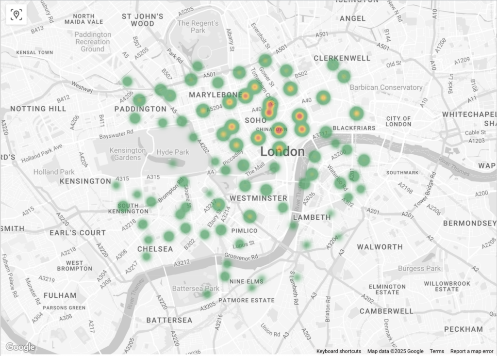
Among other capabilities, Places Insights can provide a high-scale density analysis through H3 hexagonal grids. This enables businesses to create heatmaps that can visualize potential areas or suitability for specific business needs. Through heatmapping, companies can easily identify “hotspots” (or areas of high commercial activity) or “cold spots” (or untapped markets).
Here’s a heatmap of coffee outlets in London which are rated over 4 and are open on Wednesdays at 4 pm.
Here’s another example of using Places Insights in a smart market solution:
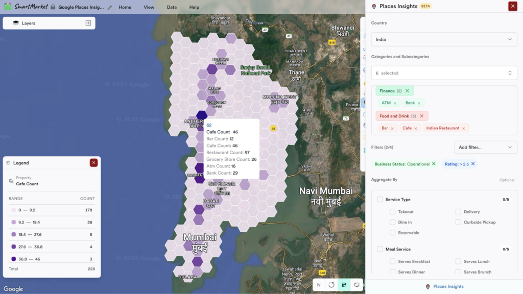
Additionally, with H3 Hexagons, retailers can create a competitive index, which compares the number of their retail outlets with those of the closest competitor within a specific hexagon.
Shifting the approach to hyperlocal analysis
Google Maps’ Places Insights effectively shifts business focus from standard geospatial analysis to hyperlocal (or street-level) analysis, which zooms into specific city blocks and intersections. Instead of state-level mapping, enterprises can combine the aggregated geospatial data with BigQuery’s computational power to understand the uniqueness and business potential of every street corner.
Here’s a 2-step process that includes:
- Defining the hyperlocal funnel.
This includes partitioning a city into hexagonal grids and running an SQL query to measure specific attributes in every grid cell; for example, count the number of coffee shops with over 4.5 ratings located within 500 meters of this metro station. This step is essential to identify areas of high business potential. - Performing “white space” analysis.
The next step is to identify locations with high consumer demand, but with low (or poor) competitor presence. By analyzing the density of a specific type of business, hyperlocal analysis can identify any existing market gaps or opportunities (for example, areas with multiple coffee shops all rated below 4 stars).
Conclusion – How Google Gemini is powering geospatial insight
The Places Insights tool brings the transformative power of Gemini’s geospatial reasoning to Google Maps. As the underlying AI layer, Gemini can process petabytes of POI data and imagery to understand the context of the physical world. Through custom, multi-step queries, enterprises can benefit from prescriptive insights that Gemini delivers.
With its expertise in Google Maps, Onix can help you leverage geospatial insights from real-time location data.Here’s a real-world case study of how an investigative company leveraged our expertise in Google Maps platform solutions.
Contact our team today.