

Large vehicle fleets, such as delivery trucks, heavy haulers, and logistics buses, face a host of operational challenges that differ from those of standard passenger vehicles. Logistics drivers need to be mindful of physical restrictions, including low-height bridges, narrow tunnels, steep turns, and roads with weight restrictions.
Besides these physical restrictions, logistics operators need to plan routes across the complex web of local, state, and federal road networks. Essentially, commercial vehicle operators have had to rely on routing solutions designed for passenger vehicles, which has led to a significant operational deficit.
The operational deficit in commercial routing
Traditional route planners (and algorithms) are optimized for the navigation of standard vehicles. They don’t account for factors that are specific to larger fleets. This operational gap forces logistics managers and drivers to rely on manual checks, cumbersome maps, and localized knowledge.
This outdated technology presents an inefficient, risky, and unsustainable solution to commercial vehicle routing and navigation. The latest launch of Google Maps Large Vehicle Routing (LVR) solves this operational deficit.
Introducing Google Maps Large Vehicle Routing
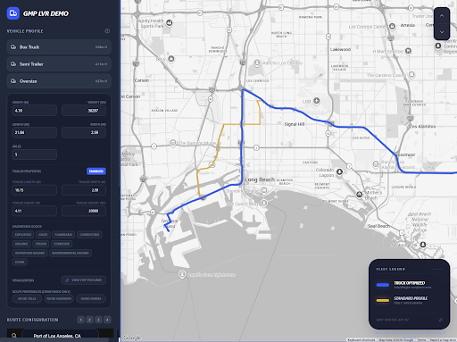
Recently announced by Google Maps, the Large Vehicle Routing (LVR) solution is now available across the U.S. What makes it unique is its seamless integration with other solutions like the Google Maps Routes API, Routes Optimization API, and Navigation SDK.
As a complete API-driven solution, LVR integrates real-world vehicle and road restrictions into its routing logic and algorithm. This feature can optimize routes that account for the physical characteristics of large commercial vehicles and real-time road restrictions.
What LVR delivers – customization and safety
Here’s what the Google Maps LVR solution makes possible for commercial vehicle operators:
- Granular vehicle profiling
Logistics companies can now specify their vehicle profile in detail, including its height, weight, dimensions, number of axles, and classification of any hazardous goods. - Commercial route optimization
Based on the specific vehicle attributes, businesses can now get an optimized route, travel time, and distance by using Google Maps’ real-time road data and traffic models. This allows them to compare various commercial routes and avoid road tools that are not commercially beneficial. - Truck-specific ETAs
With the introduction of its vehicle-specific ETA model, Google Maps has now combined the observed speeds of large vehicles with real-time and predictive traffic data, thus providing more accurate estimates for the arrival of large vehicles.
From dispatch to the last meter – optimizing the logistics
Here’s how this Google Maps routes planner can optimize operations using its various APIs:
- Route tokens
Through LVR’s route token, logistics operators can address the “disconnect” between their back-office dispatches and the driver’s in-vehicle navigation. They can pass the details of any restriction-aware route from the Google Maps Routes API to the Navigation SDK, thus ensuring that the driver is executing the exact routing plan. - Macro-level orchestration
With Google Maps’ route optimization API, operators can plan for single (or multi-stop) routes and multi-vehicle fleets (on a daily or weekly basis). Along with efficient routing, LVR can optimize for time, mileage, and other constraints – based on the number of stops, vehicles, and any vehicle-specific restrictions. - In-app driver navigation
The Google Maps Navigation SDK enables an integrated, in-app navigation experience for commercial vehicle drivers, along with familiar Google Maps guidance. Features like feature callouts allow drivers to identify any restrictions along the route, along with turn-by-turn navigation and visual enhancements about restrictions regarding vehicle height or weight limits.
Conclusion
With its new LVR solution, Google Maps is delivering exceptional efficiency for the benefit of large commercial vehicles, available in the US. Through its precision and intelligence, it can optimize the route for any fleet of delivery vehicles, including those planning to transport a heavy haul or hazardous materials.
As a Google Maps Premier Partner, Onix can help you optimize your truck routing using Google Maps, thus ensuring maximum operational efficiency, cost savings, and safety. Our team of experts can audit your current logistics software. Contact us to get started!