Across the globe, physical infrastructure is becoming more challenging to understand and analyze for deeper insights. Infrastructure operators face common challenges with infrastructure management, such as high cost and time-consuming field dispatches. Remote sensing technologies are beneficial but difficult to scale due to challenges with capturing and analyzing real-time geospatial data.
For instance, if you’re part of any field service operations in any utility company, there’s the constant challenge of understanding the current state of your physical infrastructure – whether that means electricity grids, road signs, or mobile cell towers. The “traditional” response is to dispatch a field service team for visual inspection on receiving any breakdown alert.
To address these challenges, Google Maps has introduced Imagery Insights as a new category of imagery datasets. Here’s how it works.
What is Google Maps’ Imagery Insights?
Companies rely on real-time geospatial data to make informed business decisions. Integrated with the Google Maps platform, Imagery Insights is designed to streamline business operations and drive smarter decision-making. This technology simplifies both decision-makers’ and data analysts’ ability to extract real-time insights by integrating Google Maps datasets into Google BigQuery.
Among the integrated datasets, Imagery Insights provides access to insights from Google Street View, which has a repository of over 280 billion images, offering 360-degree and 3D views of infrastructure. Spanning over 100 countries, Google Street View allows companies to extract insights from its imagery without any physical field surveys.
With its seamless integration with Google BigQuery, Imagery Insights also enables advanced spatial analysis of the available imagery. It can also connect to Vertex AI, thus allowing users to automatically identify physical assets and assess their condition for improved infrastructure management. Hosted on Google Cloud, Vertex AI can connect directly to Google Street View imagery to identify and monitor the condition of infrastructure assets, including telephone poles, street signs, roads, and bridges.
As an example, a telecom company can leverage Imagery Insights to locate its mobile towers virtually and determine if they need any maintenance work.
Enhancing Google Maps imagery with AI
As a technology, AI can transform massive volumes of geospatial data into actionable intelligence. Here’s how companies can utilize AI to create realistic, immersive imagery for a variety of applications:
- Photorealistic 3D mapping
With AI technology, enterprises can now create realistic 3D maps and models. AI-powered systems can merge thousands of 2D images from different angles and apply high-resolution texture to make the final 3D image look more realistic. - Object identification
Enterprises can use AI and computer vision technology to automatically identify and categorize real-world objects from Google Street View and satellite imagery. These objects include street signs, road signs, traffic lights, and utility assets like mobile towers and telephone poles. This enables them to monitor real-world environments and extract real-time data for various points of interest (POIs). - Data processing and efficiency
Besides object recognition, AI can be used to automate manual tasks like image correction and color balancing. It can automatically run quality control to detect and correct image anomalies and blurring, thus improving the quality of maps. - User experience
With AI-enhanced imagery, users now have an intuitive, immersive way to explore various locations. Besides, it can provide contextual information on the map, thus helping users to make informed decisions.
Monitoring infrastructure virtually with Google Maps’ Imagery Insights
As an integral part of the Google Maps Platform (GMP) ecosystem, Imagery Insights captures and combines real-time insights from a variety of geospatial sources. Here are some of its highlights:
- Street View provides the essential “ground view” of the condition of every physical asset.
- Satellite Imagery provides the historical view of any asset, along with changes over time.
- Photorealistic 3D Maps provide a real-world context for efficient planning and visualization.
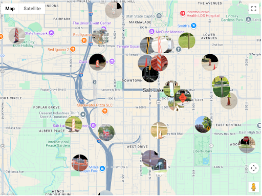
Here’s a real-world map interface for a selected service territory with marked cone locations.
With Imagery Insights, you can virtually audit your physical assets from your desk (or remote location). Among the key benefits, field service teams can assign their technicians exclusively to physical assets that require urgent maintenance or repair. This is easily achievable by querying the location of every asset (in a particular state or city) and identifying issues such as rust, damage, or any vegetation overgrowth.
Eliminating utility pole inspections with AI-enabled infrastructure monitoring
Here’s a tangible example of how a telecom company can leverage Google Maps’ Imagery Insights to audit its network of over 50,000 utility poles. Without this AI-powered tool, this process would run into months of physical inspections.
With Imagery Insights, all that it takes is to run a simple query in GMP against the Imagery Insights dataset. In a matter of minutes, the tool delivers a comprehensive report on all the utility poles – along with details of any visible damage (including those damages obscured by surrounding trees). You can retrieve this valuable information and provide it to the field service technician before they visit the site.

By using over 280 billion images from Google’s Street View along with AI-enabled analysis, utility companies can also identify damaged assets, any missing equipment, and maintenance requirements from their office premises. This helps reduce inspection costs by up to 70%.
Effectively, by shifting from manual, physical inspection of utility assets to remote monitoring, companies can unearth a host of benefits to boost their ROI. Here are some of them:
- Massive cost savings
Utility companies can reduce the volume of site surveys to inspect their assets, thus saving millions in their annual operational budget. - Operational efficiency
Utility companies can use Imagery Insights to optimize their logistics and route planning, thus ensuring that they send their maintenance teams to the right place, at the right time, and with the right maintenance equipment. - New revenue streams
Companies using Imagery Insights can unlock new revenue streams from their massive database of geospatial data. For instance, they can explore new location-based services or develop field service tools (powered by Augmented Reality).
Conclusion
By leveraging the power of Google Maps Platform and AI technology, companies now have the perfect combination to break free from the endless cycle of reactive maintenance and on-site dispatches.
The arrival of Imagery Insights is a significant “leap forward” for Google Maps customers, who can leverage its visual imagery into an intelligent, queryable resource to manage their infrastructure. Additionally, its integration with Google BigQuery and Vertex AI opens new avenues for data-driven decisions and operational excellence. In reality, Google Maps’ Imagery Insights can enable you to build a data-driven, proactive, and resilient strategy to manage your assets and infrastructure. As a Google Maps partner, Onix brings years of expertise in geospatial solutions for the benefit of its location-based customers. Are you looking for a reliable partner well-versed in Google Maps platform solutions? Contact our team today.