As Onix continues to champion the transition to Agentic AI, the year 2026 is also about integrating the Google Maps platform with AI-enabled solutions. As a trusted Google Maps partner, Onix remains committed to innovations in the domain of geospatial reasoning and location-driven intelligence.
2026 also marks a shift from selling geospatial solutions to addressing real-world problems, most notably the lack of real-time monitoring of infrastructural assets. Onix’s combined know-how of Google Maps and “data +AI” gives us a unique competitive advantage to address geographical challenges.
Here’s a dive into how Onix is set to execute its “Data + AI + Geo” vision in 2026.
How Onix is propelling its 2026 vision
Ajay Ranipeta will be leading the GeoAI and Geospatial initiatives. Previously, Ajay worked as a Google Developer Specialist for Google Earth Engine. He brings over 20 years of domain experience in building large-scale global informatics systems, including one for biodiversity conservation for the U.N. He is excited about the prospects of using geospatial reasoning and GeoAI for “finding the best cafes around the neighborhood, finding optimal routes for multiple delivery trucks, or counting the number of ships at a port.”
To help Ajay realize this vision, the Senior Technical Director of AI and data science at Onix will be working with him to integrate machine learning and advanced analytics into Google Maps. Ajay will be supported by the data science team to make location data strong with AI, as “location data becomes exponentially more valuable when paired with predictive AI.”
Meet Onix’s rebuilt Geo team for 2026 and beyond
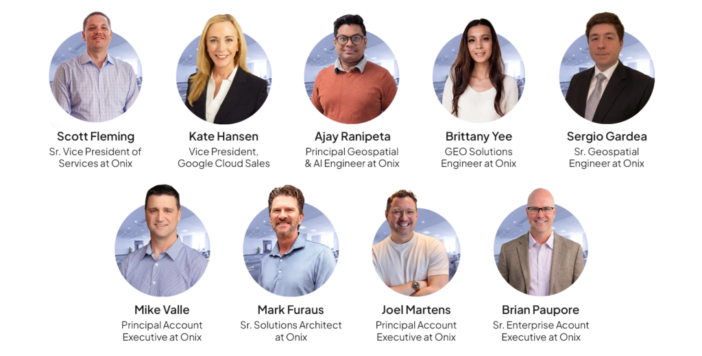
To implement its “Data + AI + Geo” vision for 2026, Onix has put together a complete team that delivers a mix of executive leadership, specialized engineering skills, and strategic accounts management. This team comprises Scott Fleming (SVP, Services at Onix) and Kate Hansen (VP, Google Cloud Sales), who bring the required executive sponsorship into this initiative. They ensure that any geospatial program is no longer a “siloed” activity, but is integrated into Onix’s cloud and data strategies.
The technical (or engineering) core of this team comprises the following:
- Ajay Ranipeta: Ajay Ranipeta joins us as the Principal Geospatial and AI Engineer, bringing over 20 years of experience in architecting large-scale global informatics systems. He has the rich experience of working as a Google Developer Expert (GDE) with Google Earth Engine, specializing in GeoAI initiatives. In this role, he bridges the gap between traditional data structures and geospatial reasoning to deliver smart, location-based solutions.
- Mark Furaus: Mark Furaus is a Senior Solution Architect involved in creating architectural designs for complex, location-sensitive systems. Bringing over 20 years of experience across various industries, he is passionate about helping organizations leverage geospatial technology to solve mission-critical challenges. His expertise ensures that clients have a solid, scalable foundation for their location intelligence initiatives.
- Sergio Gardea: Sergio Gardea is a Senior Geospatial Engineer providing hands-on expertise in deploying customized geospatial solutions. Operating at the intersection of geospatial technology and cloud platforms, he specializes in translating complex spatial data into practical business outcomes. He is passionate about moving beyond basic mapping to show how location intelligence drives critical enterprise decisions.
- Brittany Yee: Brittany Yee is a dedicated geospatial specialist who will be responsible for supporting strategic account growth and customer success. Drawing on a decade of experience ranging from desktop applications to advanced web APIs within the Google Maps Platform, she ensures clients get the most out of their implementations. She is a passionate advocate for mapping technology and is eager to drive innovation for our customers.
Besides, this team will be supported by the sales and account growth team, comprising Joel Martens & Mike Valle (as principal account executives) and Brian Paupore as the senior enterprise account executive. They are responsible for guiding customers through commercial strategy and license optimization.
As part of cross-functional collaboration, this Geo team will work closely with the “Data & AI” team. The Data & AI team will actively work on various Geo projects and help them build smarter, predictive solutions. This collaboration will enable “clients to go beyond mapping ‘what happened’ to predicting ‘what will happen.’” The team also highlighted the immense potential of transformative solutions combining Google Maps’ “rich location intelligence with Vertex AI’s modelling and agent capabilities.”
The intersection of Geo, Data, and AI – Onix’s competitive advantage
With its varied expertise in developing Google Maps platform solutions, Onix has a distinct advantage in integrating:
- Geospatial data (or the “what”)
- Google Maps (or the “where”)
- Artificial intelligence (or the “prediction”)
Effectively, this intersection allows AI agents (or vertical solutions) to make instant decisions based on real-time location data. Michael Valle points out the value of the “integration of over 280 billion Google Street View images with Google BigQuery and Vertex AI.” These valuable insights can facilitate “automated detection, assessment, and monitoring of critical assets and traffic conditions.”

As illustrated in the image, AI-powered insights can eliminate expensive field visits by maintenance teams and assess real-time infrastructure conditions automatically.
Here is an example of how Onix solutions can tackle the “pothole” problem:
Each year, municipal authorities lose millions as a result of infrastructural failures. Among the cases, Los Angeles paid $5 million in pothole-related settlements in 2022, while U.K. authorities paid over £32 million between 2017 and 2021 for road-related injuries.
To address this problem, Onix’s solution includes:
- Geospatial imagery data (using satellite or Street View) to monitor any asset.
- AI-powered computer vision to automatically detect any road degradation at an early stage.
- Predictive maintenance to schedule the next visit by maintenance operators, thus saving both damage and time.
Onix’s solution can be applied to other use cases, including retail site selection, supply chain optimization, and sustainability tracking.
Conclusion
Driven by its 2026 Propel vision, Onix is set to accelerate its thrust in the geospatial domain and address complex infrastructure-related problems for its customers. By converging expertise in geospatial and AI technology, Onix has assembled the right mix of experts to pursue this vision.
You have an opportunity to meet our new team at upcoming events, specifically this year’s Google Next event. Get in touch with us for any enquiries.